 |
| Cachora, the gateway to Choquequirao from the south |
After waiting to pick up laundry (i.e. everything I own) and leaving last minute instructions for Sarah to meet us in Huancacalle in 7 days, a string of cars and buses finally dropped Trinity and me in Cachora. We were ready to start our Choquequirao trek... around 3:30pm. Right on time! Before leaving Cusco, we had consulted the SAS offices (our tour group from Salkantay) to get info on the trail. The office personnel knew little more than costs, but we caught up with a guide who gave us details. He left out one major detail- that this was going to be one of the most spectacular
and physically demanding treks of the trip. One detail he did include was there was a landslide in April that had washed out a bridge and no one was sure if there was a way across the river- but we figured we would cross that bridge when we got to it, literally. As we began hiking in twilight we noted how many huge mud, rock and landslides covered the road or stole parts of it away and dropped them thousands of feet below. The song "Landslide" began playing immediately on repeat in my head for the entire week.
 |
| Stunning views of the Salkantay range as we hike a few hours from Cachora before sunset |
Camped out on a lush plateau several thousand feet above the valley floor with a backdrop like this and mountains seeming to crumble all around us, we already knew that the Choquequirao trek was going to end up high on our lists. The real trek began day two for us, descending switchbacks to Rio Apurimac... little did we know it was going to be a perpetual ascent/descent combination for the next few days. We kept our eyes peeled for the destroyed bridge but we spotted the massive rockslide first. Before arriving at the river, we were stopped to sign a release form:
 |
| Trinity signing her life away, fingerprint included, acknowledging that there are "seasonal dangers on the trail" |
 |
| First glimpse of the bridge and we were envisioning American Gladiator type moves, seriously hoping that our upper body strength wouldn't fail us... |
 |
| ...but then we realized they had installed a cable car alternative. Phew! |
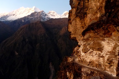
Winter solstice was only a few days away but it still felt like summer deep in the jungle with the sun pounding down. We had received many offers for mules to carry our bags, but it wasn't until mid-ascent that I realized we were probably the only people who turn down that offer. The trail climbed about 1500 meters in less than 8 kilometers to Marampata. Choquequirao was
just around the corner as we set up camp and enjoyed a hot meal with a local family and an anthropologist from Lima hiking with his poodle. A morning (unguided) tour of the ruins was topped only by hot lunch at the top. There is a serene silence that accompanies a place with such a past and mountains with so much depth. The advantage of Choquequirao over Machu Picchu was definitely the self-exploration and the fact that we only saw two other tourists on the site. Known as the "2nd Machu Picchu" about 60% of the ruins are still covered in thick jungle overgrowth since excavation only began in the 70's.
 |
| The trail zigzag up the opposite side of the valley to begin the ridiculous ascent |
 |
| Refusing to get out of the sleeping bag with so many mosquitoes around! |
 |
| The old man at Maizal shared potatoes and corn for lunch. The other land owner fled with his family after two huge mudslides in April took out land on both sides of their house |
 |
| The disturbed land from the many slides is prime real estate for the lupins |
 |
| Massive cliffs (and drops) kept our jaws dropped the entire descent to Yanama |
 |
| One of our best lunch spots- roses and glaciers! |
 |
| Towering peaks before Kelca Machay |
 |
| Incan highway, paved with huge rocks, started as we ascended the final pass |
 |
| Looking back through the valley |
 |
| Pack animals are not allowed on the Incan Trails in an attempt to keep them in good shape |
Highs:
- Seeing a Condor fly 20 meters overhead, definitely the closest we have gotten!
- Following original Inca trails and imagining how much work they were to build
- Since arriving in Peru, buses seem to leave when we want and go where we want
- Home cooked meals along the way- potatoes, eggs, even fresh fried trout in Yanama! (A lot of the local villages have trout farms)
- The squeal of guinea pigs in all the local houses... they are adorable but soon to be eaten!
- A 15 year old girl followed us out of Cachora telling us about local plants and herbs
- After 10 days of silence, Trinity's voice finally came back!
- Taking a video waking up in the morning at one of our more fabulous campsites.. we decided we really need more videos (and we will figure out how to post them at some point)
- Hiking with a poodle!
- One of the best hospedajes, Sixpac Manco, randomly in small town Huancacalle but the Señora made us wonderful vegetarian meals and dished out the cups of tea in her pleasant courtyard garden
- Feeling like the intense climbs were whipping our butts into shape
- Getting praised from all the guides and locals that we passed for how fast we are: "Caminan bien!"
Lows:
- After getting a lesson from the local girl on plants, I picked some "muña" (mountain mint) to make tea that night. I must have missed something in the lesson (like don't use the flower part?) because my muña wasn't even drinkable
- The steep descents were hard on the knees and ankles, especially with the land falling away from under you
- Being back in the land of free-roaming cows, they still shake me up a bit since we got charged outside of Cochrane
- Camera died on the last day- luckily we still had the Droid (which we have been using with additional navigational tools but are sending back with Sarah to cut weight)
- Getting a huge blister on my heel- it has been months!
- Kids persistently begging for candy and chocolates... they don't even offer up a hello, just "dame dulces"
- Ascending 2300m nearly all in one day
- After the trek, Trinity reading a book about Vilcabamba (the area we were in) that showed a picture of a man holding up a huge Boa that he had killed in this area... we hadn't even added being constricted to death to the list of worries about sleeping in the open on the jungle trail!
FYI Choquequirao Trekking Times
Cachora to Chiquisca 4 hrs
Chiquisca to Rio Apurimac 30 mins (quoted 2 hrs)
Rio Apurimac to Santa Rosa 2 hrs
Santa Rosa to Marampata 2 hrs
Marampata to choquequirao 1 hr
Choquequirao to Rio Blanco 3 hrs
Rio Blanco to Maizal 3 hrs
Maizal to San Juan Pass 4 hrs
Pass to Yanama 1.5 hrs
Yanama to Cholgana (?) 2 hrs
Cholgana (?) to Kelca Machay 3.5 hrs
Kelca Machay to Choquecatarpo Pass 2.5 hrs
Pass to dirt road (end Incan Trail) 1.25 hrs
Road to Huancacalle 3 hrs
*NOTE: We don't hike extremely fast but we
don't break either
We reached Huancacalle in 5 days, 2 hrs as opposed to our predicted 7 days. The plan was to meet Sarah in the "plaza" but upon arriving we realized this strange little town did not have a plaza. It looked like government houses that sprang up over night but we couldn't figure out what it would be for. On top of it all, we called Sonnet back in the states who relayed an email from Sarah that she was still in Lima. We did find the only lodging in town charming and made friends with a few local guides. When we told them our plan was to continue to Espiritu Pampa they looked concerned and sincerely warned us against the trek. Apparently "narco-terroristas" (
Shining Path) occupy a lot of that region and there have been a few recent incidents with them. I was curious to know what would happen to us if we did continue, but the only response we got was "better not to find out" and "next year may be better." Locals have warned us about a wide variety of things in the last 9 months on the trail but this was the first time we actually scratched a trek all together. We might be crazy but we aren't dumb. Change of plans- Trinity and I headed to Ayacucho to meet back up with Sarah.
 |
| Huancacalle.. Shelley thinking "Hmm... is Sarah really going to make it to this town in the middle of nowhere??" |


Exhilarating and beautiful scenery!
ReplyDeleteReally, you couldn't make this stuff up. A poodle, peaks that make me swoon even sitting here on the prairie, Incan highways, that amazing light, and photos that just keep getting more astonishing. Bless you for being flexible about not going on to Espirtu Pampa. Another time ...
ReplyDeleteI am jealous, this just keeps getting better!
ReplyDeleteMy post was deleted? It seemed so innocuous . . .
ReplyDelete~Shelley
Shelley-
DeleteSo sorry! We don't know what post you are referring to? We received one comment from you a while back "Delighted to have found your smart, beautiful blog from Gossamer Gear's web site. I look forward to continuing with you (vicarously, alas) for the rest of your incredible journey. -Shelley" which was posted on "Southern (Hemisphere) Hospitality" back in March- I remembered seeing it specifically because we share a great name!! Apologies if somehow another post was deleted, I don't think we ever had a chance to see it!
No worries! I hiked from Cachora to Espiritu Pampa several years ago, and I enjoyed returning (via this post) to some of the places I visited on that trip. I continue to be a big fan of your blog and your adventure, chicas.
DeleteGodspeed,
Shelley
Thanks so much for taking the time to share your adventure. Wow!
ReplyDeleteWow , it is a Great Post.
ReplyDeleteAs Choquequirao Tour Guide I recommend to considerate always rich the campsites nemed by this web and others .
If you need more info : www.inkaltitude.com have a good information about Choquequirao.
kind regards .
CHASKA TOUR GUIDE
Great post!
ReplyDeleteThanks for all of the info. You have provided relevant information about Choquequirao.
Choquequirao trek machu picchu
This comment has been removed by the author.
ReplyDeleteBingo could be a game that depends fully on fate. taking part in keno on-line has clad to be gigantically illustrious currently associate degreed an ever increasing variety of people square measure seeing the sport united of the foremost fascinating on the nightrush.ca club games. whereas the bigger a part of the people play keno for the sake of diversion, there square measure people WHO have confidence this the sport as a significant indulgent field.
ReplyDeleteI think that the author's experience is very interesting, and I can relate to a lot of what she went through. It's tough love, but I think it's worth it in the end.
ReplyDeleteChoquequirao tour